In English
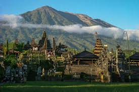
Gunung Agung (Mount Agung) is the highest mountain on the small Indonesian island of Bali. Although peaks rise higher on Irian Jaya, Sumatra, Lombok, and Java, Bali's status as Indonesia's most popular tourist destination makes Agung perhaps the most-climbed high peak in the country.
Agung is a volcano with an enormous and very deep crater that occasionally vents out smoke and steam. The highest point is on the southwest part of the rim, a barren and rocky hill of fine volcanic rock. The summit area is above the treeline, due to the high winds and sterilizing effects of recent volcanic activity, but it is my understanding that the summit never sees any snow. Still, the weather of the surrounding rainforests of Bali is almost always cloudy, and the potentially awesome view of the entire island spread out beneath you is extrmely rare. Rinjani (12,224'/3726m) on the neighboring island of Lombok is often visble above the clouds, though. The most commonly given altitude for Agung is 3142m/10,308', but this is an old elevation that does not take into account a volcanic eruption in 1963. When I was on Bali, I calibrated my altimeter to zero at sea level, and found the summit to be 2920 m. I reset it to 3142 m, but back at sea level it read -222 m. I had nver experienced my altimter to be that far off, so was stumped until someone saw my account on the web and told me that the real elevation is 3014 m, so my altimeter was only off by 94 m, still a bit, but not as bad as I thought.
In Balinese
In Indonesian
⏤
https://www.peakbagger.com/peak.aspx?pid=11010
Photo Credit: Komang Pramana


Enable comment auto-refresher